Phushrey Lake
Location
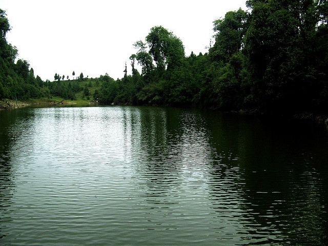
Phushrey Lake is situated a few kilometres from Aritar, amidst the forests. There is an old log, reflecting its beautiful image in the water of the lake.
Topic
Phushrey Lake is situated a few kilometres from Aritar, amidst the forests. There is an old log, reflecting its beautiful image in the water of the lake.
The Rayong Sunrise View Point is situated 8 km away from the town of Ravangla, on the road to Damthang. This view point provides a panoramic view of the surroundings and a very good view of the sunrise at the place. The first rays of the sunrise at this place lighten up the peaks of Mt. Narsing, Jopuno, Kabur, Rathong and Pandim.
Tendong Hill is a small flat expanse of land lying at an altitude of 8,530 ft. surrounded by lush green ancient forest. Historically, this has been a place of recluse for Buddhist Lamas who spend years in meditation amidst the peaceful scenic grandeur.
The Maenam Hills is one of the trekking points of Ravangla Town and is situated at an altitude of 10,300 ft. The surroundings of this hill provide a view of Mt. KhangchenDzonga, as well as of many other richly forested and rugged hills. On clear sunny days, from this hill, one can also view the Bengal plains, spread between Kalimpong and Darjeeling hills.
Menam Hill towers above Tendong Hill on the other side overlooking the Ravangla bazar settlement. Situated at an altitude of 10,300 ft. the scenic view from this height is, perhaps, unmatched in this part of the world.
Borong Tsa Chu and Ralong Hot Springs are popular sightseeing attractions of this destination. Both of these attractions are situated at a distance of 7 km from each other. These are the natural spas and are believed to have strong curative powers.
Mt. Katao, near Lachung, is visited by many tourists, especially those interested in recreational activities like snowboarding, skiing, snow tubing and stone grinding.
Rimbi Waterfalls are approximately 12 km away from Pelling and further about 5 km from the Darap Village. They are situated along the banks of Rimbi River.
These waterfalls lead into the Rimbi River, famous for activities like fishing.
The Yumthang River is a popular tourist attraction in the Yumthang Valley. Also known as Yumthang Chu, this river flows through the Shingba Rhododendron Sanctuary.

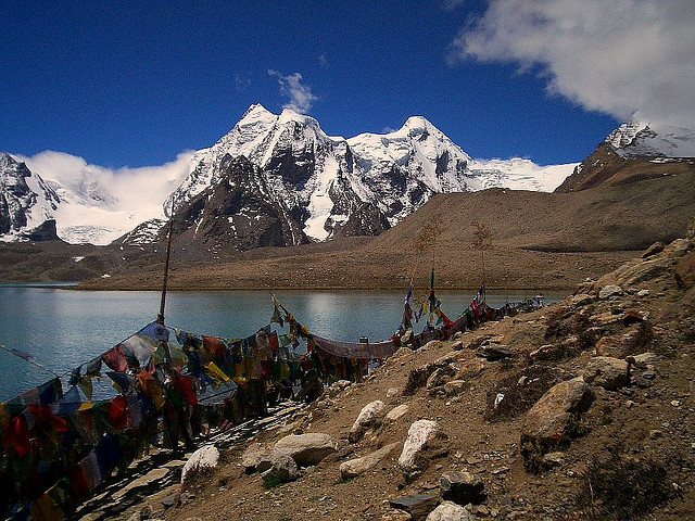
Gurudongmar Lake is sacred to Hindus and Buddhists. It is situated at an altitude of 17,100 feet, close to the Indo-China border. This milky white lake is supposed to be blessed by Guru Rimpoche or Guru Padmasambhava, who is revered as the patron saint of Sikkim. The unique feature of this lake is that a small portion remains unfrozen, even at the peak of winters.
Gurudongmar Lake is the biggest and one of the highest lakes in Sikkim. The lake is situated at a height of 17,100 ft and rests on the northern part of the Kanchenjungha Range. The name of the lake was adopted from the name of Guru Dongmar.

The Muguthang Valley forms the end part of the trek route from Chopta Valley and is situated in its east. This Valley is situated at an altitude of 15500 ft. Its surroundings provide a view of flat pastures, criss-crossed by a number of snow-fed streams and mountains. The place is primarily liberal from habitations however; certain Tibetan nomadic settlements are still seen here. It is also home to rare species of high altitude ruminants and their predators.