
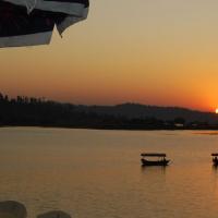
Andaman Nicobar Islands, adorning the seas on the eastern side of Indian mainland, is the archipelago of 572 emerald islands, islets and rocks. The territory's capital is the Andamanese town of Port Blair.
The union territory is 150 km north of Aceh in Indonesia and separated from Thailand and Burma by the Andaman Sea. The northernmost point of the Andaman and Nicobars group is 901 km away from the mouth of the Hooghly River and 190 km from Burma. The southernmost island, Great Nicobar's southernmost point, called Indira Point, lies only 150 km from Sumatra in Indonesia.
States of India

Andhra Pradesh, sometimes referred to as the "Rice Bowl" of India, is the fourth largest Indian State by area and has Hyderabad as its capital along with the adjoining twin city Secunderabad, is the largest city in the state. The State has the second longest coastline (972 km) among all the States in India.
Andhra Pradesh is divided into three regions. The northern part of the plateau is the Telangana region and the southern part is known as Rayalaseema. These two regions are separated by the River Krishna. The third region is Coastal Andhra. It is composed of most of the eastern half of the Deccan plateau and the plains to the east of the Eastern Ghats. It has has two major rivers flowing through it - the Krishna and Godaveri rivers.

Arunachal Pradesh, located in the far northeast, is bordering the states of Assam and Nagaland to the south, and shares international borders with Burma in the east, Bhutan in the west, and the People's Republic of China in the north. The state also known as 'Land of the Dawn-lit-Mountains' is the first Indian soil to greet the morning sun.
It is a mysterious, magical and mystical land and is one of the most compelling holiday destinations in India and has Itanagar as its capital. It is mainly a tribal society, Mongoloid and Tibeto-Burmese stock being the primary tribal population.
Geographically, much of Arunachal Pradesh is covered by the Himalayas. It beckons you to enjoy your holidays in its picture-perfect hills and valleys.

Assam, formerly the Assam Province (British India), is a northeastern state and is one of the most culturally and geographically distinct regions of the country. It is endowed with lush greenery with the mighty Brahmaputra and the Barak River valleys defining the State. Dispur is the capital city of the state of Assam.
The state is divided into three broad geographic units: the lower and central Assam hills (known as the Shillong Plateau), the Barail ranges and the low hilly terrains of Mizo hills and the Alluvial valley of Brahmaputra, Dhansiri and the Barak river.

Bihar, formerly known as Magadha, lies mid-way between West Bengal in the east and Uttar Pradesh in the west and has Patna as its capital. It is a land of great mythological and historical importance with great contributions in the field of religion / spiritualism and governance.
Bihar has been the cradle of ancient Indian history. The first major empire, the Magadh Empire, rose on the soil of Bihar. It is the land where Buddhism was born and Lord Mahavira preached his philosophy among the masses. One of the most important religious places in India, Bodh gaya, is located in here. It is the place where lord Buddha delivered his first sermon. It also has the credit of having one of the largest universities of its time: Nalanda University.

Chandigarh, also called the 'City of Gardens', serves as the capital of two states, Punjab and Haryana. The city of Chandigarh was the first planned city in India and is known internationally for its architecture and urban design. It is located near the foothills of the Shivalik range, the outermost edge of the Himalayas in northwest India.
Chandigarh derives its name from the Chandi Mandir, the temple of goddess Chandi located in the Panchkula district.

Chhattisgarh, formerly a part of Madhya Pradesh was formed on November 1, 2000 as the 26th state of the Indian Union with Raipur as its capital. It borders the states of Madhya Pradesh on the northwest, Maharashtra on the west, Andhra Pradesh on the south, Orissa on the east, Jharkhand on the northeast and Uttar Pradesh on the north. The natural beauty of the state combined with ancient caves and the unique tribal population make it a popular tourist destination.
Dadra and Nagar Haveli is a Union Territory in western India. Individually, Dadra and Nagar Haveli are two unconnected regions separated by the industrial township of Vapi in Gujarat. Nagar Haveli is the larger of the two comprising the town of Silvassa. Nagar Haveli is wedged between Maharashtra and Gujarat, whereas Dadra is an enclave lying a few kilometres north of Nagar Haveli in Gujarat.

Daman & Diu, the second smallest Union Territory of India, is located on the west coast and surrounded by the Arabian Sea. Bordered by water in four sides, Diu finds the land of Gujarat in its North. On the other hand, Daman is guarded by Gujarat in the East and seawater touches its West coast. Daman & Diu were part of the Portuguese territories in India, and joined the Indian Union in 1961.
Image Credit: http://www.flickr.com/photos/jungle_boy/160140059/

Delhi, has a history dating back at least 2,500 years, is is the largest metropolis by area and one of India's fastest growing cities. It is an expansive area, in its extremity it spans from Narela in the north to Ghitorni in the south. Najafgarh is the furthest point west, and Seemapuri is its eastern extremity.
The name Delhi is often also used to include urban areas near the NCT, as well as to refer to New Delhi, the capital of India, which lies within the metropolis.

Goa, former Portuguese colony, is situated on the west coast in the region known as the Konkan (which is an escarpment rising up to the Western Ghats range of mountains, which separate it from the Deccan Plateau) and is India's smallest state by area. The state was liberated from Portuguese rule in 1961 and became a part of the Indian Union territory along with Daman and Diu and became the 25th independent state of India on 30th May 1987. Panaji is the state's capital, while Vasco da Gama is the largest city.
Goa with only two districts South Goa and North Goa, is bordered by Maharashtra in the north, Karnataka in the south and east, and the Arabian Sea on the west. Panaji is the headquarters of the North Goa district and Margao of the south district.

Gujarat, one of the most industrialized states in India, is situated on the west coast (most of which lies on the Kathiawar peninsula) and is bordered by Rajasthan to the north, Maharashtra to the south, Madhya Pradesh to the east and the Arabian Sea as well as the Pakistani province of Sindh on the west. Its capital is Gandhinagar, while its largest city is Ahmedabad. It came into existence as a separate State on 1st May 1960.
It can be divided into three geographical regions: the eastern region that has the major cities of Ahmedabad, Surat and Vadodra; the Saurashtra region between the Gulf of Cambay and the Gulf of Kutch; the northern region of Kutch which is a salty desert.

Haryana, once the home of legendary Bharata dynasty from which got the name Bharat to India, is is a landlocked state in northern part of the country was created off Punjab on 1st November 1966. The capital of the state is Chandigarh which is administered as a union territory and is also the capital of Punjab.
Historically, it has been a part of the Kuru region where the epic battle of the Mahabharata between the Pandavas and the Kauravas, was fought at Kurukshetra (a famous religious spot in Haryana).

Himachal Pradesh, renowned as Deva Bhumi (the land of gods), is situated in Northern India and is landlocked by the Indian states of Jammu and Kashmir on the north, Punjab on the west and south-west, Haryana and Uttar Pradesh on the south, Uttarakhand on the south-east and by the Tibet Autonomous Region on the east. Shimla is the state capital and once the summer capital of the British Raj.
The state is dominated by three main mountain ranges namely the Dhauladhar Range, Pir Pinjal Range and the Great Himalayan Range. Beautiful landscapes having fresh water lakes, gushing rivers, snow capped mountains, flowers and fruits laden trees, glaring and colorful diversity of culture, arts, living style of people etc make Himachal Pradesh, a tourist's paradise.

Jammu and Kashmir is the northernmost state and is situated mostly in the Himalayan mountains,
bounded on the South by Himachal Pradesh and the Punjab, on the South West and West by Pakistan, on the North by Chinese Turkistan and a little of Russian Turkistan, and on the East by Chinese Tibet - thus strategically bordering the territories of three countries - Russia, China, and Pakistan.
The state consists of three regions: Jammu, the Kashmir valley and Ladakh. Srinagar is the summer capital, and Jammu is the winter capital. Jammu's numerous shrines attract tens of thousands of Hindu pilgrims every year while the Kashmir valley is famous for its beautiful mountainous landscape and Ladakh is renowned for its remote mountain beauty and Buddhist culture.

Jharkhand, carved out of the southern part of Bihar on 15 November 2000, is a state in eastern India and shares its border with the states of Bihar to the north, Uttar Pradesh and Chhattisgarh to the west, Orissa to the south, and West Bengal to the east. Ranchi is the capital city of Jharkhand, earlier it was the summer capital of Bihar during the British rule.

Karnataka, originally known as the State of Mysore, is a state in South West India and is bordered by the Arabian Sea to the west, Goa to the northwest, Maharashtra to the north, Andhra Pradesh to the east, Tamil Nadu to the southeast, and Kerala to the southwest. The state was created on 1 November 1956 and Bangalore (now called Bengaluru) is the capital city.
Geographically, the state has three main regions: the coastal plains abutting the sea of Karavali; the Western Ghats running parallel to the coastline comprising the hilly Malenadu region; and the inland plains of the Deccan Plateau known as Bayaluseeme region.

Kerala is located on the lush and tropical Malabar coast of south-west India, formed on 1st November 1956 by the States Reorganisation Act by combining various Malayalam speaking regions. It is bordered by Karnataka to the north and northeast, Tamil Nadu to the east and south, and the Arabian Sea on the west. Thiruvananthapuram is capital city of the state.
Geographically, the state is wedged between the Lakshadweep sea and the Western Ghats and can be divided into three climatically distinct regions: the eastern highlands (rugged and cool mountainous terrain), the central midlands (rolling hills), and the western lowlands (coastal plains).

Lakshadweep, formerly known as the Laccadive, Minicoy, and Amindivi Islands, is an archipelago of coral islands and open reefs located 200 to 440 km off the coast of the South West Kerala and is the smallest Union Territory of India. The main islands are Kavaratti (where the capital city, Kavaratti, is located), Agatti, Minicoy, and Amini.

Madhya Pradesh, often called the Heart of India, is a state in central India came into existence on November 1, 1956. It is bordered by the states of Uttar Pradesh to the northeast, Chhattisgarh to the southeast, Maharashtra to the south, Gujarat to the west, and Rajasthan to the northwest. Bhopal is the capital city of the state.
Geographically, the state straddles the Narmada River, which runs east and west between the Vindhya and Satpura ranges; these ranges and the Narmada are the traditional boundary between the north and south of India.
http://http://www.indiaunveiled.in/node/272/editwww.flickr.com/photos/e…http://www.flickr.com/photos/felixdance/5032428225/in/photostream

Maharashtra is the third largest state by area in India and is bordered by the Arabian Sea to the west, Gujarat and the Union territory of Dadra and Nagar Haveli to the northwest, Madhya Pradesh to the northeast, Chhattisgarh to the east, Karnataka to the south, Andhra Pradesh to the southeast, and Goa to the southwest. Mumbai, the capital city of the state, is India's largest city and the financial capital of the nation.
Geographically, the state consists of two major divisions: the plateau, which is a part of the Deccan tableland and the Konkan coastal strip abutting on the Arabian Sea. It stretches from the west coast to the interior regions and its climate too varies with its geography.
Image Credit:
http://www.flickr.com/photos/ryanbrookes/3174329689/

Manipur is a state in northeastern India and bounded by Nagaland to the north, Mizoram to the south and Assam to the west; it also borders Burma to the east. Imphal is the capital city of the state.
Manipur, literally meaning "A jeweled land", is an oval shaped valley at the centre surrounded by hills, rich in art and tradition with nature's beauty landscapes. Its rich culture excels in every aspects as in martial arts, dance, theater and sculpture.

Meghalaya, literally means the Abode of Clouds, is situated in the north-eastern region of India, between the Brahmaputra valley in the north and the Bangladesh in the south and came into existence as a state on 21st January 1972. Shillong, also known as the Scotland of the East, is the capital of the state.

Mizoram is one of the Seven Sister States in North Eastern India and came into existence as a state on 20th February 1987. It shares borders with the states of Tripura, Assam, Manipur and with the neighboring countries of Bangladesh and Burma. Aizawl is the capital city of the state.
Mizoram is a land of rolling hills, valleys, rivers and lakes and is a beautiful place due to its dramatic landscape and pleasant climate.

Nagaland is a state in the far north-eastern part of India and was established on 1st December 1963. It borders the state of Assam to the west, Arunachal Pradesh and part of Assam to the north, Burma to the east and Manipur to the south. Kohima is the capital city of the state and the largest city is Dimapur. It is largely a mountainous state.

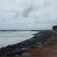
Orissa, located on the east coast of India, by the Bay of Bengal, was established on 1st April 1936. Bhubaneswar is the capital of Orissa.
Orissa is a beautiful state with several amazing tourist destinations. It is blessed with around 500 km long coastline and has some of the most beautiful beaches in the world. The landscape of Orissa is dotted with a large number of temples.
http://www.flickr.com/photos/infanticida/6708566867/in/photostream
Pondichéry, also known as "The French Riviera of the East", is a Union Territory of India and a former French colony located along the Coromandel Coast of Bay of Bengal.
http://www.flickr.com/photos/infanticida/6713012741/in/photostreamhttp://www.flickr.com/photos/infanticida/6713015251/in/photostream
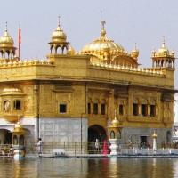
Punjab, known as land of five rivers, is a state in the northwest India and is bordered by Himachal Pradesh to the east, Haryana to the south and southeast and Rajasthan to the southwest as well as the Pakistani province of Punjab to the west, it is also bounded to the north by Jammu and Kashmir. During partition in 1947, the larger half of Punjab went to Pakistan and the Indian smaller half was further divided into three: Punjab, Haryana and Himachal Pradesh in 1966. Chandigarh is the capital of the state.

Rajasthan, literally means a Land of Kingdoms, is located in the northwest of India and is the largest state of India was formed on 30 March 1949 with Jaipur as the state capital. It is bordered by Pakistan to the west, Gujarat to the southwest, Madhya Pradesh to the southeast, Uttar Pradesh and Haryana to the northeast and Punjab to the north.
Geographically, the great Thar Desert is replete with arid plains and shifting sand dunes while the rugged Aravallis form the backbone of Rajasthan.
Rajasthan is famous for its majestic forts, intricately carved temples, and decorated havelis, which were built by Rajput kings in pre-Muslim era. It is often called a shopper's paradise and is famous for textiles, semi-precious stones and handicrafts.
Image Credit:

Sikkim is a landlocked North-eastern state nestled in the Himalayan mountains, bodering Nepal to the west, China's Tibet Autonomous Region to the north and east, and Bhutan to the southeast and West Bengal to the south. It's capital and largest city is Gangtok.
Sikkim is a land of rich and varied scenic beauty, magnificent mountains, eternal snows, dark forests, green fertile valleys, raging torrents and calm, placid lakes. The Himalayan mountains surround the northern, eastern and western borders of Sikkim.

Tamil Nadu is located in the southernmost part of the Indian Peninsula and is bordered by the union territory of Pondicherry, and the states of Kerala, Karnataka, and Andhra Pradesh. Its capital and largest city is Chennai. Geographically, is bound by the Eastern Ghats in the north, the Nilgiri, the Anamalai Hills, and Palakkad on the west, by the Bay of Bengal in the east, the Gulf of Mannar, the Palk Strait in the south east, and by the Indian Ocean in the south.

Tripura is a landlocked hilly state in northeastern India, surrounded by Bangladesh on the north, south, and west and the Indian states of Assam and Mizoram lie to the east. It was formerly an independent Tripuri kingdom and was merged with independent India on 15th October 1949 by the Tripura Merger Agreement. The capital of the state is Agartala.
The state is covered by picturesque hills and dales, deep and green valleys which have added beauty to its landscape.

Uttar Pradesh, is a state located in the northern part of India, shares an international border with Nepal to the north and bounded by Uttarakhand, Haryana and Delhi to the north and northwest; Rajasthan on the west; Madhya Pradesh on the south; Chhattisgarh and Jharkhand on the south east; and Bihar on the east. Lucknow is the capital city of the state.
Uttar Pradesh has been one of the cultural hubs of India and has several religiously significant sites, both to Hinduism and Buddhism. It is the birthplace of Hindu gods Ram (Ayodhya) and Krishna (Mathura) and the place where Buddha preached his first sermon (Sarnath).

Uttrakhand, formerly Uttaranchal, is a state in the northern part of India, formed on November 9th, 2000 (formerly a part of Uttar Pradesh). The state borders the Tibet Autonomous Region on the north, Nepal on the east and Uttar Pradesh to the south and Himachal Pradesh to the north west. It is often referred to as the "Land of Gods" due to the many holy Hindu temples and cities found throughout the state. Dehradun is the capital of the state.
Geographically, the state lies on the southern slope of the Himalaya range and most of the northern parts of the state are part of Greater Himalaya ranges, covered by the high Himalayan peaks and glaciers.
Image Credit:
http://www.flickr.com/photos/24643703@N00/2847418941/

West Bengal is a state in the eastern region of India, bounded on the north by Sikkim and Bhutan, on the east by Assam and Bangladesh. On the south by the Bay of Bengal and on the west by Orissa, Bihar and Nepal. The state was created as a constituent state of the Indian union on 15th August 1947 as the result of partition of the undivided British Indian province of Bengal into West Bengal. It stretches from Himalayas in the north to the Bay of Bengal in the south. Kolkata is the capital city.